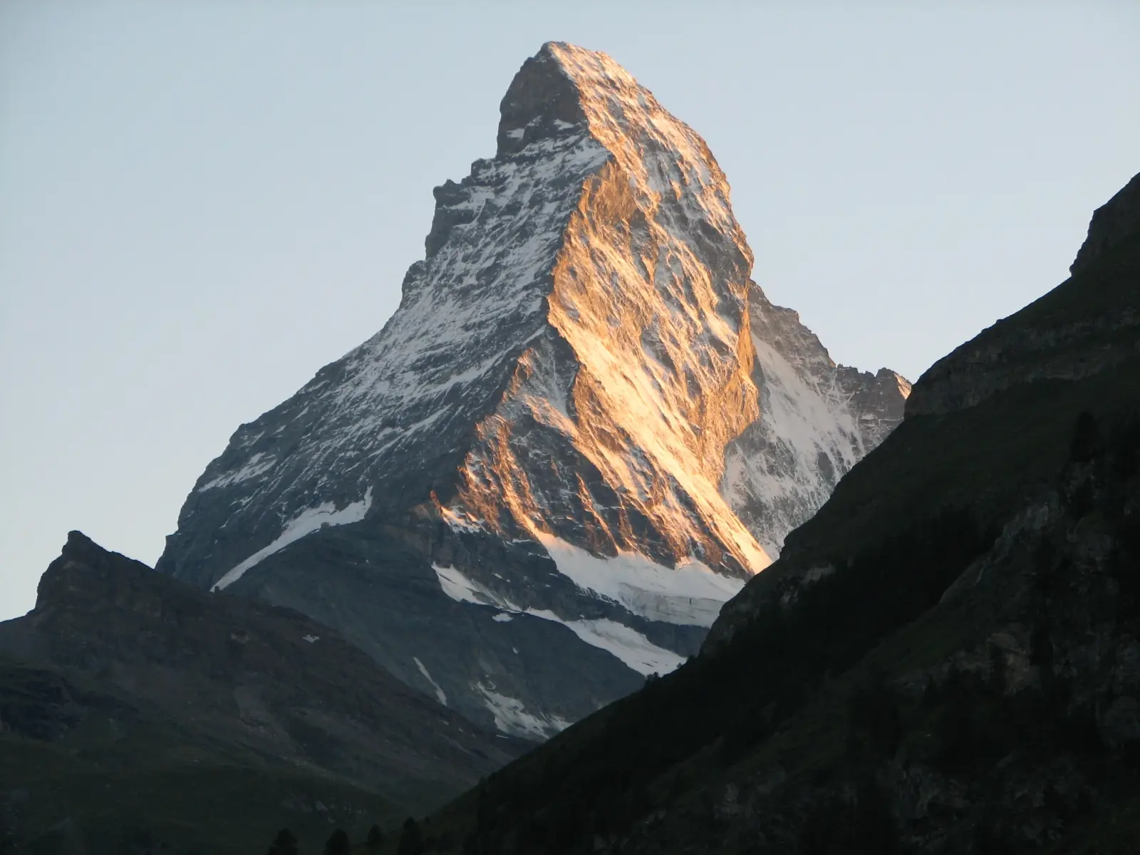
Matterhorn is one of the most famous peaks in the Alps, rising to 4478 m on the border between Switzerland and Italy. Its sharp pyramid shape makes it instantly recognizable and a major symbol of alpine mountaineering. The mountain stands above the resort of Zermatt in the canton of Valais and attracts hikers, climbers, and photographers from around the world.
Although the summit is not a trekking objective for casual walkers, the area around Matterhorn offers some of the best high-mountain trails in Switzerland, with glacier views, alpine lakes, and dramatic ridgelines. The peak is also a classic climbing goal, known for its exposed routes, changeable weather, and serious alpine conditions.
Access is usually through Zermatt, a car-free mountain town with rail connections and a strong mountaineering infrastructure. From there, visitors can choose scenic hikes, guided ascents, or technical climbs depending on experience and season. The mountain remains a demanding but highly rewarding destination for prepared travelers.
No ascent logs yet. Be the first to log your climb!
The best-known trekking options around Matterhorn are scenic alpine walks rather than summit hikes. The 5-Seenweg is a popular loop above Zermatt with views of the peak reflected in mountain lakes. It is moderate, well marked, and suitable for fit hikers in summer. Another classic is the trail to Hörnlihütte, which follows the lower approach used by climbers and gives close views of the north face. For longer outings, the Europaweg offers a multi-day traverse with dramatic panoramas of the valley and surrounding glaciers.
The standard ascent is the Hörnli Ridge from Hörnlihütte, the most frequently used route and the normal choice for guided climbers. It is a long alpine climb with steep rock, fixed ropes, and exposed sections, requiring sure footing and good weather. The Lion Ridge on the Italian side is another historic route, generally considered more technical and less commonly used. Both routes demand glacier travel skills, climbing experience, and early starts. The mountain is not suitable for casual hikers, and conditions can change quickly even in summer.
The nearest major populated area is Zermatt, a car-free resort town in the Valais region. Most visitors arrive by train via Visp or Täsch, then continue by shuttle train to Zermatt. The usual starting point for the summit route is Hörnlihütte, reached on foot from the Schwarzsee cable car station or by a demanding hike from the valley. Trekking routes often begin directly from Zermatt or from lift stations such as Sunnegga and Gornergrat, depending on the chosen trail.
Guided ascents are strongly recommended for the summit and are usually arranged through established alpine operators in Zermatt. Well-known providers include Alpine Guides Zermatt, Mountain Exposure, Swiss Mountain Guides, and Summit Climb. Typical prices for a private guided ascent range from about CHF 1,200 to CHF 2,500 per person, depending on group size, route, and services included. Multi-day packages with hut accommodation, equipment, and logistics can cost more. Prices vary by season and guide availability, so advance booking is important.
The best climbing season for Matterhorn is usually from July to early September, when snow conditions are more stable and mountain huts are open. In this period, the rock is generally drier and the standard routes are most accessible. Early summer can still bring snow and ice on the upper sections, while late season often means colder temperatures and shorter weather windows. For trekking around the mountain, June to September is the main hiking season, with the most reliable trails and lift access. Weather should always be checked carefully before any attempt.
For trekking near Matterhorn, hikers should carry sturdy boots, layered clothing, rain protection, sun cream, water, and a map or GPS. For the summit, full alpine equipment is required: helmet, harness, rope, crampons, ice axe, gloves, headlamp, and suitable mountaineering boots. A warm insulated layer is essential because temperatures can drop sharply at altitude. Many climbers also use trekking poles for the approach and a small pack with food and emergency items. Guided teams often provide technical gear, but personal clothing and footwear must still be appropriate.
Plan extra days in Zermatt for weather delays, since summit attempts often depend on a short stable window. Book huts and guides early in the season, especially for July and August. Acclimatization is important, so many climbers spend time on easier peaks or high trails before attempting the summit. For hikers, start early to avoid afternoon storms and crowded cable cars. Cashless payment is common in the region, but carrying a small amount of Swiss francs is still useful. Respect local trail rules, stay on marked paths, and be prepared for rapid weather changes at altitude.
Matterhorn was first climbed in 1865, and the ascent became one of the most famous events in alpine history. The mountain has four steep faces and a near-perfect pyramid shape, which makes it one of the most photographed peaks in the world. It is also one of the most dangerous major Alpine summits, with a long history of accidents caused by exposure and weather. The peak stands on the border between Switzerland and Italy, and its image is widely used in tourism, branding, and even on chocolate packaging.
How long does it take to climb Matterhorn? A guided summit climb usually takes 8 to 12 hours from hut to summit and back, depending on route, conditions, and pace.
How long does it take to approach Matterhorn? The approach to Hörnlihütte from Zermatt or Schwarzsee usually takes 2 to 4 hours on foot, depending on the starting point.
Is there cell service and internet on the Matterhorn? Coverage is available in parts of the Zermatt area and sometimes on lower sections, but it becomes unreliable higher on the mountain. Do not depend on it for safety.
How difficult is it to climb Matterhorn? It is a very difficult alpine climb with exposed rock, route-finding, and altitude. It is suitable only for experienced climbers or clients with a professional guide.
Can beginners hike Matterhorn? Beginners can hike the surrounding trails, but they should not attempt the summit route without mountaineering experience and a guide.
How many people climb Matterhorn? Thousands of climbers attempt the mountain each year, but only a portion reach the summit because of weather, conditions, and the route’s difficulty.
No posts yet.