Dent d'Herens rises to 4,173 m on the border between Italy and Switzerland, in the western Pennine Alps. It is a remote, glaciated peak known for its long approaches, serious alpine terrain, and wide views toward the Matterhorn and Monte Rosa. The mountain is less crowded than nearby 4,000-meter peaks, which adds to its appeal for experienced climbers seeking a quieter objective.
The Italian side is reached from the Valpelline area in Valle d'Aosta, with access typically starting from the Place Moulin reservoir. Most ascents involve glacier travel, crevasse awareness, and a high mountain hut or bivouac. It is not a hiking summit in the usual sense, but a demanding alpine climb with changing snow and ice conditions.
Because of its altitude and isolation, the mountain requires good fitness, stable weather, and solid mountaineering skills. The best-known routes are classic glacier and mixed climbs, usually done with a guide or by very experienced alpinists. The setting is wild and scenic, with a strong sense of remoteness throughout the approach and ascent.
No users yet
No ascent logs yet. Be the first to log your climb!
There are no true trekking routes to the summit of Dent d'Herens, since the mountain is a technical alpine objective. The closest non-technical option is the long approach walk from Place Moulin to the mountain huts in the upper Valpelline, which is popular with strong hikers and mountaineers. This approach is scenic, steady, and remote, with lake views, moraine paths, and high-alpine terrain.
For trekkers, the most attractive route is the valley walk toward Rifugio Aosta and the glacier basin below the peak. It is best described as a high-mountain approach rather than a hike to a summit. Expect several hours of ascent, limited facilities, and no marked tourist infrastructure beyond the main valley trail and hut access paths.
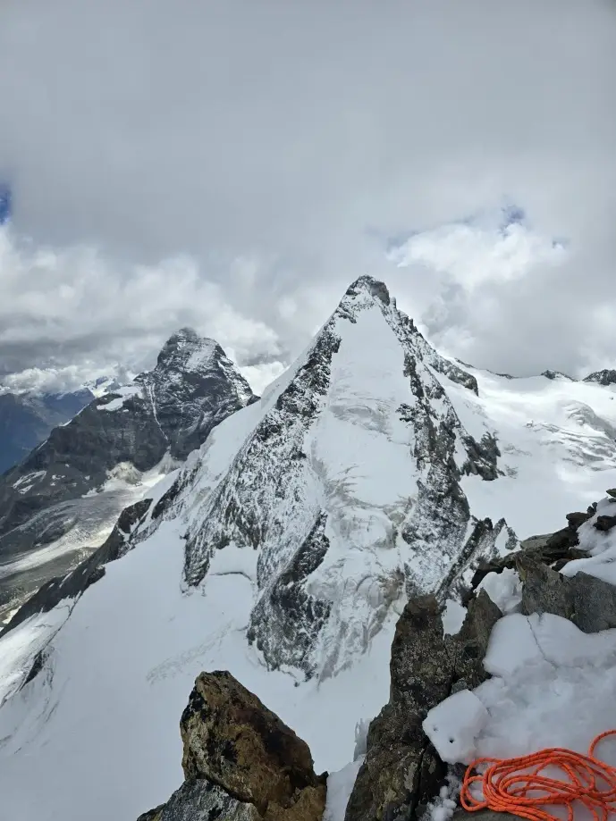
The classic route on Dent d'Herens is the normal route from the Italian side via the Hörnli-style glacier terrain of the upper basin, usually starting from Rifugio Aosta or a bivouac. It involves glacier travel, crevasse navigation, and a final steep section on snow and mixed ground. Conditions vary greatly, and the route is best attempted in stable weather with early starts.
Another well-known line is the West Ridge, a more technical and committing route with exposed climbing on rock, snow, and ice. It is less frequently climbed than the normal route and requires strong alpine experience. Both routes are serious objectives, and the mountain is often chosen by climbers looking for a quieter alternative to more famous peaks nearby.
The nearest populated area on the Italian side is Valpelline, in Valle d'Aosta. Most ascents begin from the Place Moulin reservoir, reached by road from Aosta. From there, climbers usually continue on foot toward the upper valley and the mountain huts. The approach is long and remote, so an early start and careful planning are essential.
To get there, travel first to Aosta by car or train, then drive up the Valpelline valley to Place Moulin. Public transport is limited, so private transfer or rental car is the most practical option. In summer, parking is available near the reservoir, but services are basic and weather can affect road access in the upper valley.
For a climb of Dent d'Herens, the most reliable support comes from certified local mountain guides in Valle d'Aosta and the Italian Alpine Guide system. Well-known operators in the region include Guide Alpine del Cervino, Guide Alpine di Breuil-Cervinia, and the Società delle Guide del Cervino. They offer private guiding, hut logistics, and route planning for experienced clients.
Typical prices for a private guide on a peak of this level often start around EUR 450-700 per day, with higher costs for technical routes, glacier equipment, and multi-day programs. Group courses or shared ascents may reduce the per-person cost. Always confirm current rates, guide ratios, and what is included, such as hut half-board, rope, and safety gear.
The best season for Dent d'Herens is usually from late June to early September, when the glacier routes are most accessible and mountain huts are open. July and August offer the most stable conditions, but they can also bring afternoon storms and warmer snow, which increases crevasse and avalanche risk on some slopes.
Early season climbs may have better snow cover, while later summer can expose more rock and ice. Because the mountain is high and glaciated, conditions can change quickly even in midsummer. A successful ascent depends more on weather windows and route conditions than on the calendar alone.
Essential equipment for Dent d'Herens includes crampons, an ice axe, helmet, harness, rope, glacier travel gear, and crevasse rescue equipment. Depending on the route, climbers may also need rock protection, ice screws, and a full alpine rack. Warm layered clothing, waterproof outerwear, gloves, goggles, and a headlamp are also necessary.
For the approach and hut stay, bring trekking boots, a sleeping bag liner, sun protection, and enough food and water for a long day. Because the mountain is remote, self-sufficiency matters. Many climbers also carry a GPS device, map, and emergency communication tool.
Plan for a long approach and start early, as Dent d'Herens is not a quick summit. Check hut availability in advance and confirm current glacier conditions with local guides or hut staff. Weather can change rapidly, so keep one flexible day in your itinerary if possible.
Cell service is unreliable in the upper valley and usually absent on the glacier. Internet access is limited to populated areas and some huts, where it may be slow or unavailable. Bring cash for huts and parking, and do not rely on mobile navigation alone. The mountain is best suited to climbers who are already comfortable on glaciated terrain.
Dent d'Herens is one of the most striking peaks in the western Alps, with a sharp, pyramid-like profile that is often compared to the nearby Matterhorn. Despite its height, it is climbed less often than many lower peaks because of its remote access and technical character. That makes it attractive to alpinists seeking solitude.
The mountain sits on the watershed between Italy and Switzerland and offers extensive views over the Valpelline, Breuil-Cervinia, and the high glaciated basins around Monte Rosa. Its name is sometimes written as Dent d'Hérens in French, reflecting the bilingual alpine geography of the region.
How long does it take to climb Dent d'Herens? A summit climb usually takes 10 to 14 hours from the hut or bivouac, depending on the chosen route, conditions, and team pace.
How long does it take to approach Dent d'Herens? The approach from Place Moulin to the upper hut area typically takes 4 to 7 hours on foot, with a long and steady ascent.
Is there cell service and internet on the Dent d'Herens? Coverage is poor to nonexistent on the mountain and glacier. Internet is generally unavailable except possibly in some huts or lower valley areas.
How difficult is it to climb Dent d'Herens? It is a serious alpine climb with glacier travel, exposure, and route-finding. It is considered difficult and suitable for experienced mountaineers.
Can beginners hike Dent d'Herens? No. There is no beginner hiking route to the summit, and the mountain requires technical mountaineering skills.
How many people climb Dent d'Herens? Numbers are relatively low compared with more famous peaks nearby. It is climbed by a modest number of alpinists each season, often with guides.
No posts yet.