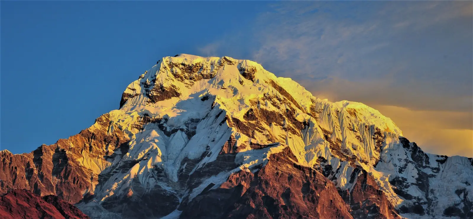
Dhaulāgiri is one of Nepal’s highest and most dramatic mountains, rising to 8,167 m in the western Himalaya. Its huge south face, long ridges, and remote setting make it a major objective for experienced trekkers and climbers. The mountain lies west of the Annapurna range and is known for steep relief, glacier travel, and serious high-altitude conditions.
The area around Dhaulāgiri offers a mix of classic trekking scenery and demanding expedition climbing. Treks here are less crowded than in central Nepal, with routes crossing valleys, high passes, and glacier basins. Mountaineering on the peak is technical and weather-sensitive, requiring strong acclimatization and careful logistics.
Access is usually arranged through Pokhara and the lower Myagdi district, with trailheads reached by road and then on foot. Because the mountain is remote, most visitors use local guides or organized agencies for permits, transport, camping support, and safety planning. The best season is generally spring and autumn, when conditions are more stable.
No users yet
No ascent logs yet. Be the first to log your climb!
Dhaulāgiri Circuit Trek is the best-known trekking route, usually taking 18–22 days. It is a demanding high-altitude trek with remote camps, glacier crossings, and the French Pass and Dhampus Pass. The route offers close views of Dhaulāgiri, Tukuche Peak, and the Annapurna range. It is suitable for experienced trekkers who are comfortable with long days, basic camping, and thin air. Shorter approaches from the Myagdi side are possible, but they still involve steep terrain and limited facilities.
The standard climbing line on Dhaulāgiri I is the Northeast Ridge, approached from the Italian Base Camp and Japanese Base Camp. It is a serious expedition route with glacier travel, avalanche exposure, and fixed rope sections near the upper mountain. The normal line is not highly technical by elite Himalayan standards, but altitude, weather, and objective danger make it very challenging. Alternative lines on the mountain are less common and are attempted only by highly experienced teams with strong support and stable conditions.
The main gateway is Pokhara, with the trailhead usually reached through Beni in Myagdi district. From Pokhara, travelers take a road journey to Beni and then continue by jeep toward villages such as Mudi or Darbang, depending on the chosen route. From there, trekking begins on foot. Access roads can be rough and affected by landslides, so extra travel time is wise. Most expeditions arrange private transport and local porters for the approach.
Trekkers need the usual Nepal trekking permits, and climbers require a Nepal Mountaineering Association climbing permit for Dhaulāgiri, plus national park or conservation fees where applicable. Hiring a licensed local guide is strongly recommended because the route is remote and weather can change quickly. Well-known agencies include Himalayan Glacier Trekking, Adventure Consultants, Seven Summit Treks, and Asian Trekking. Trek packages for the circuit often start around USD 1,800–3,500, while full climbing expeditions commonly range from USD 12,000 to 25,000+ depending on support, oxygen, and logistics.
The best climbing windows for Dhaulāgiri are spring, from April to May, and autumn, from late September to November. Spring usually offers more stable snow conditions and a better chance of summit attempts, while autumn brings clearer skies and colder, drier weather. Winter is extremely cold and risky, and the monsoon season from June to August brings heavy rain, poor visibility, and unstable slopes. Trekkers also prefer spring and autumn because river crossings, trail conditions, and mountain views are generally better.
For trekking, bring sturdy boots, layered clothing, a warm sleeping bag, rain protection, trekking poles, gloves, sunglasses, and a headlamp. For climbing, add crampons, ice axe, harness, helmet, ascender, ropes, avalanche safety gear, and high-altitude clothing rated for severe cold. Expedition teams also need tents, cooking equipment, fuel, and oxygen for summit attempts if planned. Because Dhaulāgiri involves glacier travel and long exposure, equipment should be tested before departure and carried in a way that allows quick access in changing weather.
Allow extra days for acclimatization and for road delays between Pokhara and the trailhead. Carry cash, as ATMs and card payments are unreliable outside major towns. Mobile coverage is limited on the route, so a local SIM or satellite communication can be useful. Water purification is essential, and trekkers should respect altitude symptoms and descend early if needed. Hiring local porters and guides supports the regional economy and improves safety. Because the area is remote, travel insurance should cover high-altitude trekking, helicopter evacuation, and expedition climbing.
Dhaulāgiri means “White Mountain” in Sanskrit, a fitting name for its massive snow-covered slopes. It was long considered one of the world’s highest mountains before more accurate surveys refined Himalayan rankings. The peak rises sharply above deep valleys, creating one of the most striking vertical reliefs in Nepal. It was first climbed in 1960 by a Swiss-Austrian-Nepali expedition. The mountain is also famous for its isolation, with long approaches and fewer visitors than the more crowded trekking regions of central Nepal.
Do I need a guide? A guide is not always mandatory for trekking, but it is strongly recommended because the route is remote and complex.
How long does the trek take? The Dhaulāgiri Circuit Trek usually takes about 18–22 days, depending on acclimatization and side trips.
Can I climb it without oxygen? Some experienced climbers attempt it without supplemental oxygen, but many expeditions use oxygen for safety and summit success.
What is the biggest risk? Altitude, avalanches, and rapidly changing weather are the main hazards on Dhaulāgiri.
No posts yet.