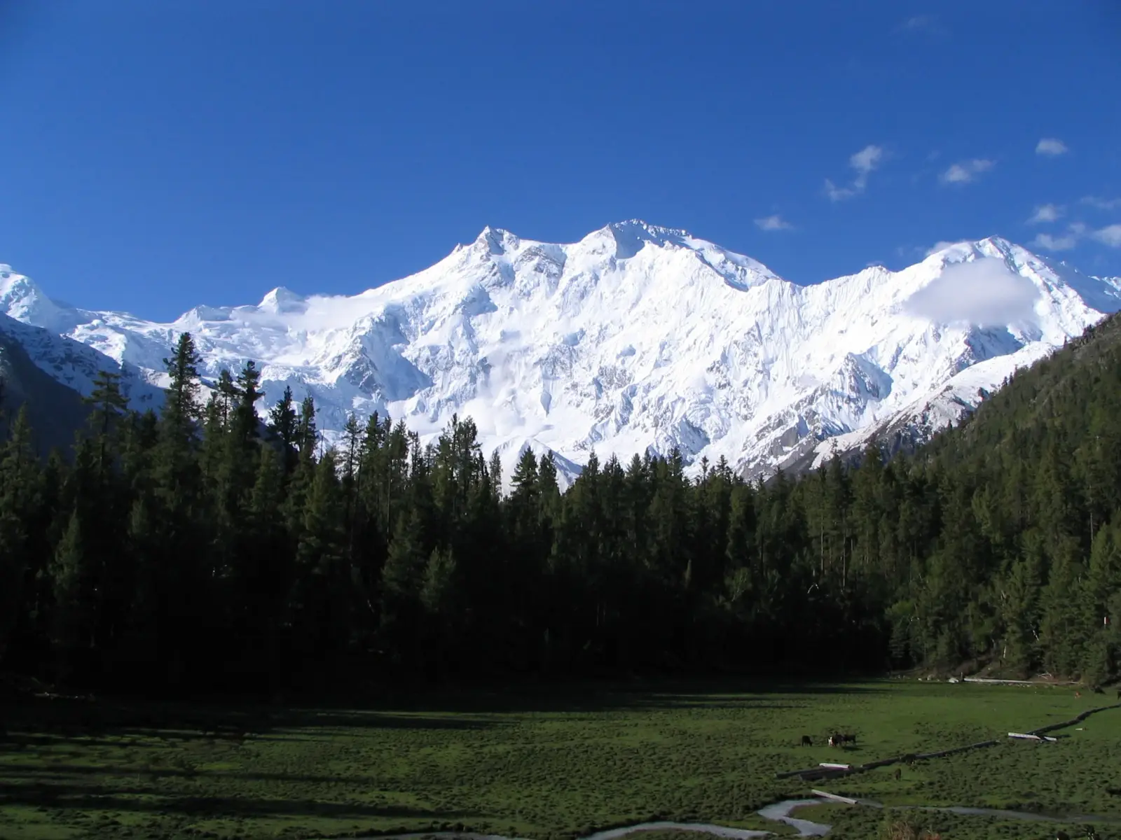
Nanga Parbat is one of the highest mountains in the world, rising to 8,125 m in northern Pakistan. It stands at the western end of the Himalayas and is famous for its huge relief, steep faces, and dramatic glaciers. The mountain is often called the “Killer Mountain” because of its difficult climbing history and severe weather.
For trekkers, the area around Nanga Parbat offers striking views of the mountain’s north and south sides, alpine meadows, and access to the Fairy Meadows region. For climbers, it is a major high-altitude objective with several demanding routes, each requiring strong technical skills, excellent fitness, and careful acclimatization.
The mountain lies in Gilgit-Baltistan, near the Diamer district, and is reached through remote mountain roads and short but rough approaches. Most visitors combine a scenic drive with a jeep transfer and a hike to base-camp areas or trekking lodges. Weather, road conditions, and local logistics strongly affect travel plans.
No users yet
No ascent logs yet. Be the first to log your climb!
The best-known trekking area is the Fairy Meadows route, which is not a summit climb but a classic approach for mountain views. The trail usually starts with a jeep ride on a narrow road from Raikot Bridge, followed by a moderate hike to the meadow. It is popular for its forest scenery, camping, and direct views of Nanga Parbat’s north face. Another option is the trek toward Rupal Valley, which is longer, quieter, and offers dramatic views of the south face. These routes are best for fit hikers with basic mountain experience.
The most famous climbing line is the Rupal Face, one of the world’s highest mountain faces and a very serious objective with steep ice, rock, and avalanche exposure. The Diamir Face is another major route, generally considered the standard line, but it still demands advanced alpine skills, fixed-rope work, and strong acclimatization. The Kinshofer Route on the Diamir Face is the best-known variation and is often used by commercial expeditions. All routes on Nanga Parbat involve high objective danger, unstable weather, and long summit days.
The nearest major populated area is Chilas, while the most common access point is Raikot Bridge on the Karakoram Highway. From there, travelers usually take a local jeep to Tato, the last road-accessible point for the Fairy Meadows approach. The final section is a hike to the meadow and then onward toward base-camp viewpoints. Reaching the area usually means flying or driving to Gilgit or Skardu, then continuing by road to Chilas and Raikot Bridge. Road travel can be slow because of landslides and mountain traffic.
Climbing Nanga Parbat requires official permits from Pakistan authorities, and foreign climbers normally arrange them through a registered expedition operator. Local guides are strongly recommended for trekking and essential for mountaineering, especially for transport, route finding, and safety in remote terrain. Well-known operators include Adventure Pakistan, Baltistan Tours, Javed Tours, and Karakoram Treks. Trekking packages to Fairy Meadows often start around USD 150–400 per person for short trips, while full climbing expeditions can cost several thousand dollars depending on support, permits, and logistics. Prices vary by season and group size.
The main climbing season for Nanga Parbat is usually June to August, when temperatures are relatively stable and the weather window is most favorable. For trekking, late spring through early autumn is best, especially May to October, with clear views often available in June and September. Snow, rain, and road closures can affect access outside these periods. The mountain is known for sudden storms, so even in the best season, teams should plan for delays and flexible itineraries. Early summer is often preferred for summit attempts, while late summer can be better for trekking comfort.
For trekking to Fairy Meadows or nearby viewpoints, bring sturdy hiking boots, layered clothing, a warm jacket, rain protection, a headlamp, sun protection, and a sleeping bag if camping. For mountaineering on Nanga Parbat, full high-altitude gear is required: insulated boots, crampons, ice axe, harness, helmet, ropes, avalanche safety equipment, glacier glasses, down clothing, and a four-season tent system. Oxygen may be used on some expeditions, but it is not a substitute for acclimatization. Because conditions change quickly, spare gloves, batteries, and waterproof storage are also important.
Plan extra days for weather and road delays, especially on the Karakoram Highway. Carry cash, as card payments are limited in remote areas. Hire a local jeep driver familiar with the Raikot Bridge road, since it is steep and rough. Start hikes early to avoid afternoon cloud build-up and to reach viewpoints in better light. Respect local customs in villages and keep noise low in camping areas. Mobile coverage is limited, so share your itinerary in advance. If you are trekking, acclimatize gradually and drink enough water. For climbers, use a licensed operator and do not underestimate the mountain’s objective hazards.
Nanga Parbat is the ninth-highest mountain in the world and rises sharply above the surrounding valleys, creating one of the greatest vertical reliefs on Earth. Its name means “Naked Mountain” in Urdu. The mountain became famous in mountaineering history because of many early failed attempts and high fatality rates. The first successful ascent was made in 1953 by Hermann Buhl, a landmark achievement in Himalayan climbing. The mountain has three major faces: Rupal, Diamir, and Raikot, each with distinct terrain and climbing challenges.
Is Nanga Parbat suitable for beginner trekkers? The Fairy Meadows approach is manageable for fit beginners, but the road and hike can still be demanding.
Can you see Nanga Parbat without climbing it? Yes, the mountain is visible from Fairy Meadows, Rupal Valley, and some points along the Karakoram Highway.
Do you need a guide? For trekking, a guide is recommended; for climbing, a professional expedition team is strongly advised.
How hard is the summit climb? It is a very difficult high-altitude ascent with serious technical and weather risks.
No posts yet.