Mount San Antonio, also known as Mount Baldy, is the highest peak in the San Gabriel Mountains of California, reaching 3068 m. It is one of the most climbed mountains in the United States because it is close to Los Angeles and offers a clear alpine feel without a remote approach. The summit area is open and exposed, with broad views over the Los Angeles Basin, the Mojave Desert, and nearby high peaks.
The mountain is popular year-round, but conditions change quickly with season and weather. In summer, hikers use dry ridgelines and steep switchbacks; in winter, snow and ice can turn the same routes into a serious mountaineering objective. The mountain is known for its long elevation gain, loose rock in places, and fast weather shifts, so even a straightforward ascent requires good planning.
Mount San Antonio is not a technical peak on standard summer routes, but it can become demanding because of distance, altitude, heat, and exposure. The mountain attracts day hikers, trail runners, snow climbers, and experienced mountaineers. Its accessibility, strong summit views, and varied route options make it one of the most important high points in southern California.
No users yet
No ascent logs yet. Be the first to log your climb!
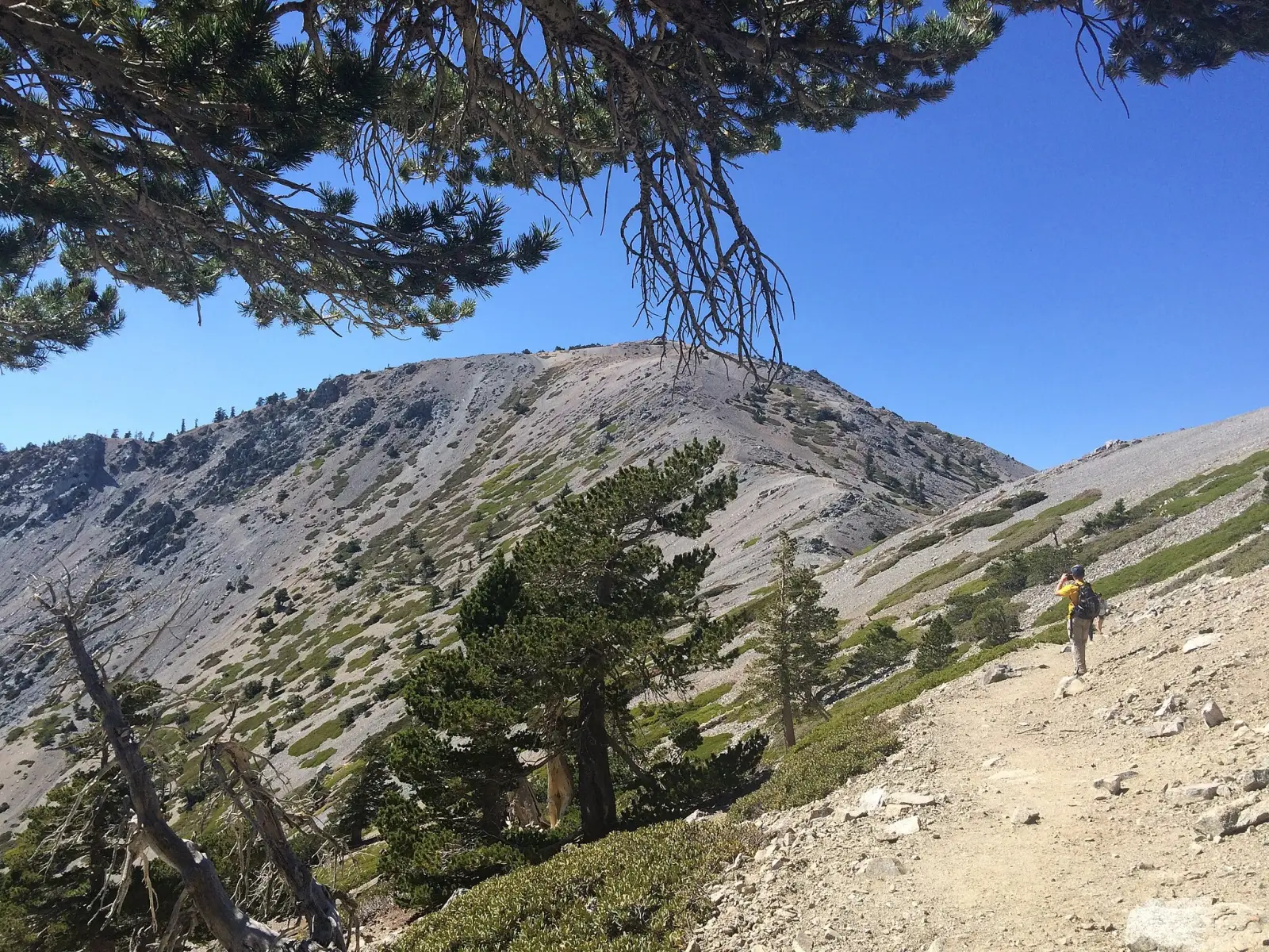
The most popular trekking route is the Baldy Bowl Trail via Mount Baldy Village and San Antonio Falls. It is steep, direct, and very popular with fit hikers who want a classic summit day. The trail gains elevation quickly, passes forested sections, and then climbs into open alpine terrain. In summer it is usually the fastest hiking option, while in winter it may require snow travel and careful route-finding.
Another common trekking line is the Devil's Backbone Trail, often used as a descent or as part of a loop. It is longer but less brutally steep than the bowl route, with wide ridge walking and big views. Hikers often combine it with the Mount Baldy Notch area for a scenic circuit. Both routes are exposed to sun, wind, and sudden weather changes, so early starts are strongly recommended.
In winter, the main mountaineering objective is the Baldy Bowl, which becomes a snow climb rather than a hike. The route is direct and efficient, but it can be hazardous because of avalanche risk, hard snow, and steep upper slopes. Climbers often use crampons and an ice axe, and conditions can change quickly after storms or warming temperatures. This is the classic line for experienced winter climbers in the area.
More advanced parties may choose variations from the bowl to the summit ridge, depending on snow coverage and stability. These lines are shorter than many alpine climbs, but they demand solid judgment because the terrain is steep and the descent can be more difficult than the ascent. In winter, the mountain is best treated as a serious mountaineering route rather than a simple hike.
The usual starting point is Mount Baldy Village, near Upland and Claremont in San Bernardino County. From there, hikers approach the trailheads for San Antonio Falls, Baldy Bowl, or the Mount Baldy Notch area. The approach is straightforward by car, and the mountain is reached from the Los Angeles region in roughly one to two hours, depending on traffic.
To get there, visitors usually drive via Mount Baldy Road. Parking is limited and can fill early on weekends and holidays, especially in good weather. Some routes begin near the village, while others use the ski area or notch access points. Road conditions can be affected by snow, closures, or fire-related restrictions, so checking access before departure is important.
For guided trips, visitors usually look for licensed local mountain guides and outdoor schools based in Southern California. Well-known providers in the region include International Alpine Guides, Sierra Mountaineering International, and REI Outdoor School when seasonal classes are available. Prices vary by group size, route, and whether the trip is a summer hike or a winter snow climb. Typical guided day trips often start around USD 150-300 per person for hiking and USD 250-500 for winter instruction or guided ascents.
Private guiding usually costs more, especially for technical snow conditions, avalanche-aware instruction, or custom logistics. Because Mount San Antonio is close to major cities, many climbers also use local mountaineering clubs and training programs rather than full-service expedition agencies. Always confirm that guides are licensed, insured, and familiar with current route conditions before booking.
The best time for a hiking ascent is usually late spring through early fall, when trails are mostly snow-free and the weather is more stable. Early summer can still bring lingering snow on shaded slopes, while midsummer often means hot conditions on the lower trail sections. For most hikers, early morning starts in May to October offer the best balance of daylight, trail access, and summit visibility.
For mountaineering, the best season is winter and early spring, when snow coverage is reliable enough for a proper snow climb. However, this is also the most dangerous period because of avalanche hazard, icy surfaces, and storm exposure. Strong winds and rapid temperature swings are common year-round, so the safest window is always the one with stable forecasts and recent route reports.
For a summer hike, carry sturdy boots or trail shoes, at least 2 liters of water, sun protection, a map or GPS, snacks, and layers for changing weather. The mountain is steep enough that trekking poles can help on both ascent and descent. Because the route is exposed in many places, a hat, sunglasses, and a light wind shell are useful even on warm days.
For winter ascents, add crampons, an ice axe, helmet, gloves, goggles, and avalanche safety gear if conditions require it. Snow can be firm in the morning and soft later in the day, so traction and timing matter. A headlamp is wise for early starts or late descents. In all seasons, carry enough water and be prepared for a long, strenuous day.
The mountain lies in a rich foothill and alpine-edge ecosystem, so wildlife can include mule deer, coyotes, bobcats, and many bird species. Higher slopes may also support mountain quail, hawks, and small mammals adapted to rocky terrain. In forested sections, hikers may see squirrels and lizards, while the open ridges are often quieter and more exposed.
Seasonal conditions affect animal activity, and early morning or evening is the best time for sightings. Hikers should also be aware of rattlesnakes at lower elevations in warmer months. Food should be stored securely, and wildlife should never be approached or fed. The area is beautiful, but it is still a wild mountain environment close to a major urban region.
Start early to avoid heat, crowds, and afternoon weather changes. On busy weekends, parking and trail access can become congested, so arriving before sunrise is often the best strategy. Check road and trail conditions in advance, especially after storms, snow, or fire closures. The summit is exposed, so even a calm morning can turn windy and cold later in the day.
Carry more water than you think you need, and pace yourself on the steep lower sections. The descent can be hard on knees, so trekking poles are helpful. If you are new to the mountain, choose a clear-weather day and a well-marked route. In winter, do not underestimate the mountain just because it is close to the city; conditions can be serious and fast-changing.
Mount San Antonio is the highest point in the San Gabriel Mountains and one of the most prominent summits near Los Angeles. Its nickname, Mount Baldy, comes from the bare summit area that often looks pale or snow-covered from a distance. The mountain is visible from many parts of southern California on clear days.
The peak is unusual because it can be a simple day hike in summer and a serious snow climb in winter. That seasonal contrast makes it especially popular with local hikers and mountaineers. The summit also offers one of the best panoramic views in the region, stretching from city basins to desert landscapes and, on very clear days, far beyond the local mountain chain.
How long does it take to climb Mount San Antonio? Most hikers need about 6 to 10 hours round trip, depending on route, fitness, and conditions. Winter ascents can take longer.
How long does it take to approach Mount San Antonio? From the Los Angeles area, the drive to the trailheads usually takes about 1 to 2 hours, depending on traffic and road conditions.
Is there cell service and internet on the Mount San Antonio? Coverage is inconsistent. Some lower areas may have service, but it can be weak or absent on ridges and in the upper mountain.
How difficult is to climb Mount San Antonio? Summer hiking is moderate to strenuous because of steep elevation gain. Winter climbing is much more difficult and can be hazardous.
Can beginners hike Mount San Antonio? Yes, fit beginners can hike it in good summer conditions if they start early, pace themselves, and carry enough water. Winter is not recommended for beginners.
How many people climb Mount San Antonio? It is one of the most popular high peaks in southern California, so hundreds of hikers may visit on busy weekends in good weather.
No posts yet.