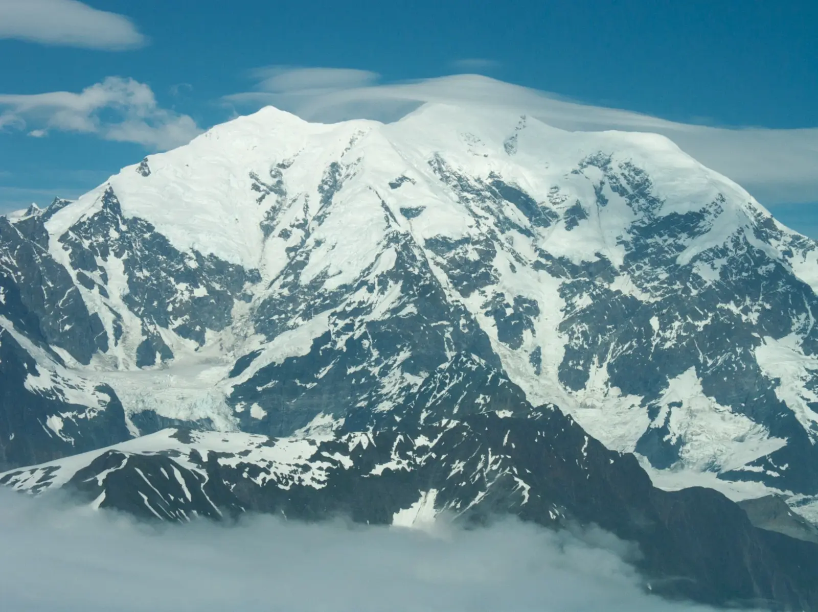
Mount Fairweather rises to 4,671 m on the Alaska–British Columbia border and is one of the most dramatic peaks in North America. It stands above the Fairweather Range inside Glacier Bay National Park and Preserve, with steep relief, heavy snowfall, and frequent storms. The mountain is remote, glaciated, and far more serious than a typical trekking objective.
There are no true hiking routes to the summit. Most visitors come for expedition climbing, ski mountaineering, or scenic flightseeing over the icefields and coastal peaks. Access is weather-dependent, and the approach usually involves aircraft, glacier travel, and a long alpine commitment. The mountain is known for its isolation, crevasses, avalanche exposure, and rapidly changing conditions.
Because of the remoteness, Mount Fairweather attracts experienced climbers rather than casual tourists. The area offers outstanding views of the St. Elias Mountains, coastal glaciers, and the Pacific margin. Even reaching base camp can take significant planning, and successful ascents depend on stable weather windows, strong navigation skills, and glacier rescue knowledge.
No users yet
No ascent logs yet. Be the first to log your climb!
There are no established trekking routes to the summit of Mount Fairweather. The lower terrain is dominated by glaciers, icefalls, and steep coastal mountains, so ordinary hiking is not practical. Visitors who want a non-technical experience usually choose flightseeing, glacier landings, or guided scenic trips in Glacier Bay National Park and Preserve rather than attempting a trek on foot.
Any approach on foot is expedition-style travel over snow and ice, not a marked trail. Route-finding is complex, and crevasses, seracs, and avalanche slopes make the area unsuitable for casual trekkers. For most travelers, the “best route” is a combination of boat or plane access to the region, followed by a guided glacier camp or a short alpine excursion in safer nearby terrain.
The standard climbing objective is the West Ridge or West Buttress-style line, depending on conditions and expedition planning. This route is favored because it offers the most direct access from the glacier systems on the Alaska side, but it still requires advanced glacier travel, rope work, and crevasse management. Expect long days, cold temperatures, and exposure to strong winds.
Other lines on Mount Fairweather are far more serious and less commonly attempted. The north and east faces are steep, heavily glaciated, and prone to storm loading and avalanche hazard. Most successful ascents are made during short weather windows in late spring or early summer, when snow conditions are more stable and daylight is long.
The nearest practical access points are Yakutat in Alaska and the coastal areas near Glacier Bay. Most expeditions begin with a charter flight or boat-supported approach, then continue by aircraft landing on a glacier or by a long alpine approach from a remote base camp. There is no road to the mountain and no village at the trailhead.
To get there, climbers usually fly to Yakutat or another Southeast Alaska hub, then arrange a bush plane, helicopter, or expedition logistics service. Weather delays are common, and landing zones can change with snow and crevasse conditions. Planning should include extra days for transport, acclimatization, and waiting out storms.
Guided ascents of Mount Fairweather are rare and usually arranged as custom expeditions rather than standard package tours. Well-known Alaska and expedition operators such as Alaska Alpine Adventures, Mountain Trip, and American Alpine Institute may help with logistics, private guiding, or custom planning. Prices are highly variable and often start around USD 10,000 to 25,000+ per person for a full expedition, excluding international travel.
Because the mountain is remote and weather-sensitive, costs depend on aircraft time, guide ratio, camp duration, and rescue coverage. Some climbers also work with local air taxi operators in Yakutat for glacier access. Always confirm current permits, insurance requirements, and guide qualifications before booking, since conditions and pricing can change significantly from season to season.
The best climbing window for Mount Fairweather is usually late spring through early summer, roughly May to July. During this period, daylight is long, temperatures are somewhat more stable, and snow bridges may still cover some crevasses. Even then, storms from the Pacific can bring heavy snowfall, strong winds, and poor visibility with little warning.
Late season attempts are less common because glacier travel becomes more hazardous as snow bridges weaken. Winter ascents are possible only for highly experienced teams and are much more serious. In all seasons, success depends on patience, flexible scheduling, and the ability to wait for a short weather window.
A climb on Mount Fairweather requires full expedition mountaineering gear: rope, harness, helmet, crampons, ice axe, crevasse rescue kit, glacier glasses, avalanche tools, and cold-weather clothing. Teams should also carry tents rated for severe wind, insulated sleeping systems, stove fuel, and navigation tools with backup power. Satellite communication is strongly recommended.
Because the mountain is glaciated and remote, climbers should be prepared for self-sufficiency. Extra food, repair kits, and emergency shelter are essential. Ski mountaineering equipment may be useful on some approaches, but only for teams with strong glacier travel experience. Standard hiking gear is not enough for this objective.
The surrounding region supports coastal and alpine wildlife, including brown bears, black bears, mountain goats, moose, and a variety of seabirds near the coast. In the marine environment, visitors may also see sea otters, seals, and whales. Wildlife sightings are more common in lower valleys and coastal areas than on the high glacier slopes.
Climbers should store food securely and follow bear-safety practices at all camps. Weather and terrain limit animal activity at higher elevations, but tracks can still appear near glacier margins. The area is part of a wild, protected ecosystem, so leave-no-trace practices are important.
Plan extra days for weather delays, because flights and glacier landings are often canceled or rescheduled. Bring a flexible itinerary and confirm evacuation options before departure. Cell service is generally unreliable to nonexistent on and around Mount Fairweather, and internet access should not be expected. Satellite devices are the safest communication option.
Permits, insurance, and guide arrangements should be checked well in advance. Climbers should be comfortable with crevasse rescue, route finding, and storm camping. For non-climbers, the best way to experience the mountain is through scenic flights or coastal viewing in clear weather. Always respect the remoteness of the area and the limits of your experience.
Mount Fairweather is the highest peak in British Columbia and one of the most prominent mountains in southeastern Alaska. Despite its name, the summit is known for harsh weather rather than fair conditions. The mountain was named by Captain James Cook in 1778, reportedly because of unusually clear skies when he first saw it.
The peak rises dramatically from near sea level, creating one of the greatest vertical reliefs in the region. Its remote position and severe climate mean that relatively few climbers attempt it each year. For many visitors, the mountain is more famous as a landmark of wilderness than as a standard climbing destination.
How long does it take to climb Mount Fairweather? Most expeditions take about 2 to 3 weeks, including weather delays, approach, acclimatization, and summit attempts.
How long does it take to approach Mount Fairweather? The approach can take several days, but transport delays and glacier access often make the total travel time longer.
Is there cell service and internet on the Mount Fairweather? No reliable cell service or internet should be expected on the mountain or during the glacier approach.
How difficult is it to climb Mount Fairweather? It is a very difficult, remote, glaciated alpine climb that requires advanced mountaineering experience.
Can beginners hike Mount Fairweather? No. There is no beginner-friendly hiking route to the summit, and the terrain is not suitable for casual hikers.
How many people climb Mount Fairweather? Only a small number of climbers attempt it each year, and successful ascents are relatively rare.
No posts yet.