No users yet
No ascent logs yet. Be the first to log your climb!
There are no true trekking routes to Gannett Peak in the casual hiking sense; most approaches are long wilderness treks that end at a climbing base camp. The most common access is via the Glacier Trail or Green River Lakes side, where hikers follow established backcountry trails through forest, meadows, and alpine basins before leaving the trail for cross-country travel. These routes are scenic, remote, and demanding, with heavy packs and multiple river crossings in some seasons.
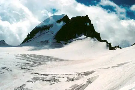
The standard ascent is usually made from the Gooseneck Glacier side, often combining the Dinwoody Glacier approach with the Gooseneck Glacier and the summit ridge. This is the most traveled line because it offers the most direct access to the summit, but it still requires glacier travel, crevasse awareness, and route-finding. Other variations may use the Koven Glacier or different basin approaches, depending on snow conditions and the party’s experience. All routes are serious alpine climbs, not technical day hikes.
The usual starting points are near Pinedale or Dubois, the nearest service towns for supplies, fuel, and last-minute gear. From Pinedale, climbers commonly drive toward Green River Lakes or trailheads in the Bridger-Teton National Forest. From Dubois, access may involve roads leading toward the Wind River Range trail system. Reaching the trailhead usually requires a high-clearance vehicle for rough forest roads, followed by a long approach on foot to establish camp before the summit attempt.
Guided climbs are available through regional mountain guiding companies that operate in the Wind River Range and greater Wyoming alpine areas. Well-known providers include Exum Mountain Guides, Jackson Hole Mountain Guides, and select independent certified guides based in western Wyoming. Typical prices vary widely by group size, season, and itinerary, but a private guided Gannett Peak climb often starts around USD 1,500 to 3,500 per person, while custom multi-day trips can cost more. Always confirm current rates, permits, and guide credentials directly.
The best time to climb Gannett Peak is usually from mid-July through early September, when snow conditions are generally more stable and the approach trails are mostly open. Earlier in the season, snow can make travel easier in some places but also increases avalanche and glacier hazards. Later in summer, streams are lower and trail access is simpler, though afternoon storms remain common. Weather in the Wind River Range can change fast, so climbers should plan for cold nights, wind, and possible snow at any time of year.
A climb of Gannett Peak typically requires backpacking and mountaineering gear: sturdy boots, layered clothing, tent, sleeping bag, stove, food, map, compass, and GPS. For the summit push, most parties carry crampons, ice axe, helmet, harness, rope, glacier travel gear, and crevasse rescue equipment. Trekking poles help on the long approach, and waterproof layers are important because storms can arrive quickly. Since the route is remote, extra batteries, repair items, and emergency shelter are strongly recommended.
The area around Gannett Peak supports classic high-country wildlife of the Wind River Range. Hikers may see mule deer, elk, bighorn sheep, marmots, pikas, and occasionally moose in lower valleys. Black bears are present in the region, so proper food storage is essential. Birds of prey, including hawks and eagles, are often seen over ridges and open basins. Wildlife encounters are usually brief, but visitors should keep distance and avoid leaving food or trash at campsites.
Plan for a long, self-supported trip and do not underestimate the approach to Gannett Peak. Check road conditions before leaving town, because forest roads can be rough or muddy. Register with local land managers if required, and carry a detailed map because cell service is unreliable or absent for most of the route. Start early for summit day to avoid afternoon weather. Acclimatization helps at 4,209 m, so spending a night or two at altitude is wise. Leave no trace, pack out all waste, and be prepared to turn back if glacier or weather conditions worsen.
Gannett Peak is the highest point in Wyoming and one of the most remote state high points in the United States. It is named after geographer Henry Gannett. The mountain is part of a dramatic alpine landscape with glaciers, lakes, and long granite ridges. Because of its isolation, reaching the summit often feels more like a wilderness expedition than a standard climb. Many climbers consider it one of the most rewarding high points in the lower 48 states.
How long does it take to climb Gannett Peak? Most parties need 3 to 5 days for the full trip, including the approach, acclimatization, and summit day.
How long does it take to approach Gannett Peak? The approach usually takes 1 to 3 days on foot, depending on the chosen trailhead, pack weight, and camping plan.
Is there cell service and internet on the Gannett Peak? No reliable cell service or internet should be expected on the mountain or most of the approach.
How difficult is it to climb Gannett Peak? It is a difficult alpine climb that requires fitness, route-finding, glacier travel skills, and comfort in remote terrain.
Can beginners hike Gannett Peak? Beginners can hike parts of the approach trails, but the summit climb is not suitable for beginners without mountaineering experience or a guide.
How many people climb Gannett Peak? Numbers vary by season, but it is a relatively low-traffic peak compared with famous mountains, and only a limited number of climbers attempt it each year.
No posts yet.