Fremont Peak rises to 4,191 m in the Wind River Range of western United States, within the rugged alpine landscape of Wyoming. The mountain is known for its remote setting, steep granite terrain, and long approaches through high-country basins and passes.
It attracts experienced hikers and climbers looking for a quiet, less-traveled objective with big views, clear alpine lakes, and exposed ridgelines. Conditions can change quickly, and most routes require solid navigation, fitness, and mountain judgment.
Unlike many famous peaks, Fremont Peak is not a crowded destination. Visitors come for solitude, technical scrambling, and classic Wind River scenery rather than developed facilities or marked trails.
No users yet
No routes yet.
No ascent logs yet. Be the first to log your climb!
The most common trekking approach to Fremont Peak follows long trails into the Wind River Range, usually combining forest paths, alpine meadows, and lake basins before reaching higher camps. These routes are scenic and demanding, with significant elevation gain and a remote feel. Hikers often use established trails toward Fremont Lake and then continue on backcountry paths toward the peak’s lower slopes.
Treks here are best suited to strong hikers comfortable with full-day efforts, route-finding, and variable weather. Trail conditions can include snow early in the season, stream crossings, and rocky sections. Most visitors treat the mountain as a multi-day backcountry objective rather than a simple day hike.
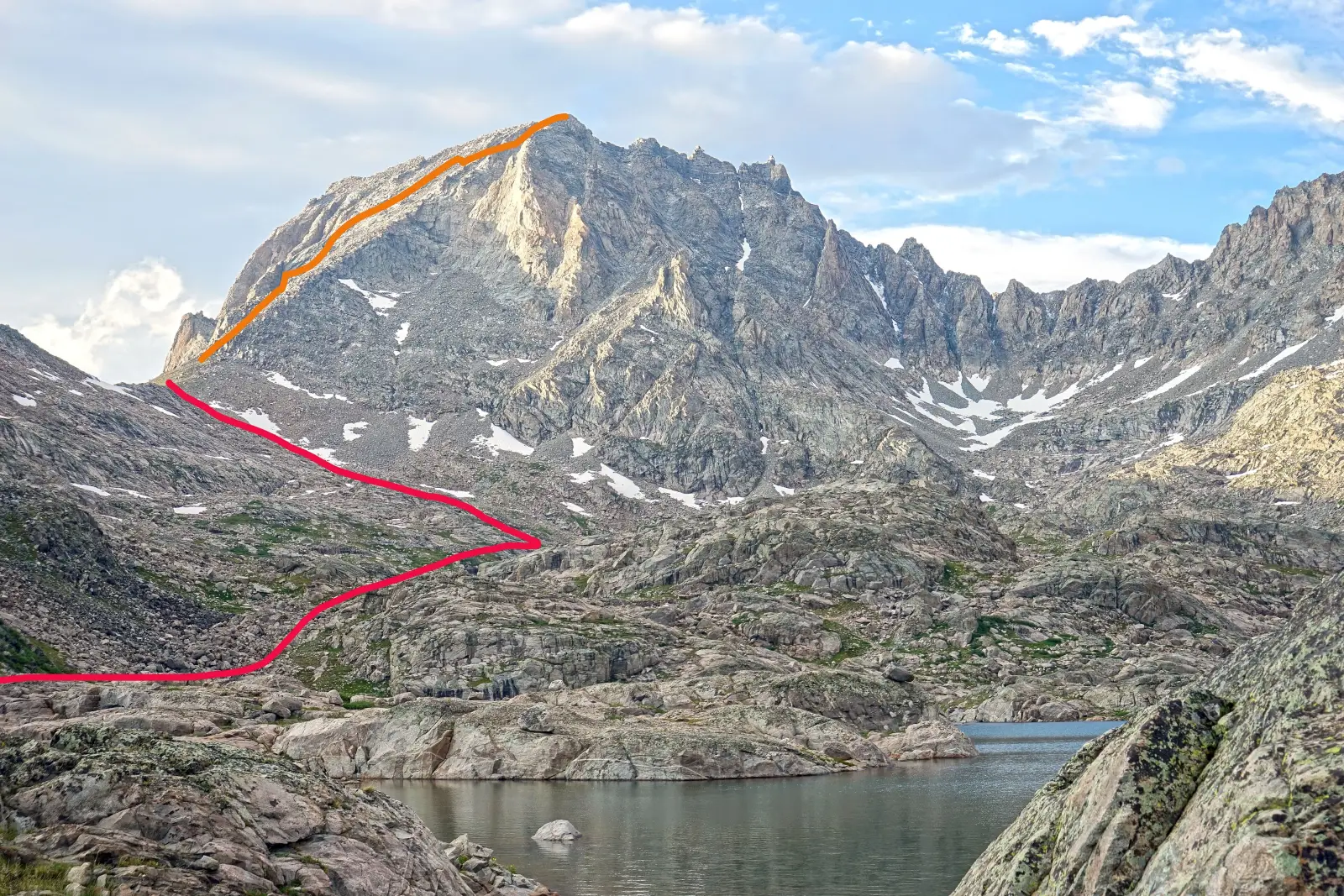
Mountaineers usually climb Fremont Peak by its standard scrambling lines on the mountain’s easier faces and ridges, depending on season and snow conditions. The ascent is typically non-technical in dry summer conditions, but it still involves steep talus, loose rock, and exposed sections where a slip could be serious. In early season, snow and ice can increase difficulty and may require traction and an ice axe.
More advanced climbers may seek steeper variations on the peak’s ridges and faces, but these are less commonly used and demand stronger alpine skills. The mountain is best approached as a serious high-altitude climb, not a casual summit walk.
The usual access point for Fremont Peak is the Pinedale area in western Wyoming, with approaches often beginning near trailheads around Fremont Lake and the southern Wind River Range. From Pinedale, travelers drive to the trailhead by paved and then forest roads, depending on the chosen route. Some trailheads are remote and may require high-clearance vehicles.
The approach is long, often taking a full day or more on foot before the climb itself begins. Most visitors arrive via Jackson Hole or Rock Springs airports, then continue by car to Pinedale. Road and trail access can be affected by snow, mud, and seasonal closures.
Guided climbs in the Wind River Range are usually arranged through regional mountain guiding companies rather than operators based directly on Fremont Peak. Well-known options in Wyoming include Exum Mountain Guides, Jackson Hole Mountain Guides, and Wyoming Mountain Guides. These companies are known for alpine instruction, route planning, and custom private trips.
Prices vary by season, group size, and objective, but private guided days in the region commonly start around USD 500 to 900 per guide per day, while multi-day custom trips can cost more. For exact pricing, clients should request a current quote, since logistics, gear, and travel time strongly affect the total.
The best time to climb Fremont Peak is usually from mid-summer to early fall, when snow has melted from many lower routes and weather is more stable. July through September is the most practical window for trekking and standard ascents. Earlier in the season, snowfields and frozen slopes can make the route more complex and increase objective hazards.
Late summer often offers the best balance of dry rock, longer daylight, and manageable temperatures. Even then, afternoon thunderstorms are common in the Wind River Range, so early starts are recommended. Autumn can be excellent, but shorter days and colder nights require more preparation.
For a climb of Fremont Peak, hikers and mountaineers should carry sturdy boots, layered clothing, rain protection, navigation tools, food, and enough water capacity for a long alpine day. A map, compass, and GPS device are important because trail junctions and upper slopes can be confusing. Trekking poles are useful on the approach and descent.
If snow remains on the route, add an ice axe, helmet, and traction such as microspikes or crampons, depending on conditions. A headlamp, emergency shelter, and first-aid kit are also recommended. Because the area is remote, self-sufficiency matters more than on popular front-country peaks.
The alpine and subalpine zones around Fremont Peak support wildlife typical of the Wind River Range, including mule deer, elk, marmots, pikas, and mountain goats in some areas. Black bears may be present in lower forested sections, so food storage and campsite cleanliness are important. Birds of prey are often seen soaring above ridges and basins.
Wildlife encounters are usually brief, but visitors should keep a respectful distance and avoid feeding animals. In summer, insects can be active near lakes and meadows, while higher elevations are generally less buggy. Early morning and evening are the best times to spot larger animals.
Plan for a remote mountain environment when visiting Fremont Peak. Cell service is unreliable or absent on most approaches and on the mountain itself, so offline maps and a satellite communicator are wise. Tell someone your itinerary before leaving, and be prepared for self-rescue if weather or injury delays your return.
Start early to avoid afternoon storms, carry extra layers, and watch for snow patches even in summer. Water sources may be plentiful in the approach basins, but always treat water before drinking. Because the route is long, many climbers camp near the approach to reduce summit-day fatigue.
Fremont Peak is one of the notable high points of the Wind River Range, a range famous for granite walls, alpine lakes, and long wilderness approaches. The area is part of a landscape shaped by glaciers, which left cirques, moraines, and sharp ridges that define the mountain’s character.
The peak is named after John C. Frémont, an explorer associated with western surveying and exploration. Despite its height and beauty, the mountain remains relatively quiet compared with more famous U.S. climbing destinations, which adds to its appeal for experienced backcountry travelers.
How long does it take to climb Fremont Peak? Most climbers need a long summit day, often 8 to 14 hours round trip from a high camp or trailhead, depending on route, snow, and fitness.
How long does it take to approach Fremont Peak? The approach commonly takes 1 to 2 days on foot, and sometimes longer if starting from a lower trailhead or carrying heavy overnight gear.
Is there cell service and internet on the Fremont Peak? No reliable cell service or internet should be expected on Fremont Peak or most of the approach.
How difficult is it to climb Fremont Peak? It is a moderate to difficult alpine objective, with steep terrain, route-finding, and possible snow or loose rock depending on season.
Can beginners hike Fremont Peak? Beginners can hike parts of the approach, but the summit climb is better suited to experienced hikers or climbers with mountain navigation skills.
How many people climb Fremont Peak? It is not a heavily trafficked mountain, so the number of climbers is relatively low compared with popular U.S. peaks.
No posts yet.