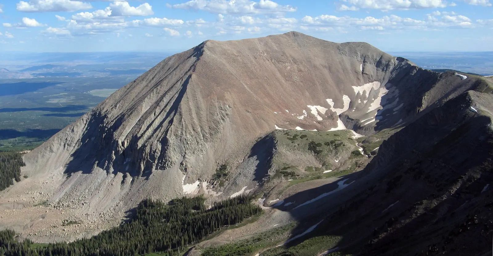
Mount Peale is the highest peak in the La Sal Mountains of southeastern United States, rising to 3877 m. It stands in a rugged alpine setting above red-rock desert country, making the mountain a striking contrast to the surrounding landscape. The summit area offers broad views toward Moab, the Colorado Plateau, and distant ranges across Utah.
The mountain is known for its remote feel, steep approaches, and changeable weather. Most visitors come for hiking, scrambling, and backcountry climbing rather than technical mountaineering. Snow can linger well into summer, and the route conditions often depend on season and recent storms.
Mount Peale is part of the La Sal Mountains, a popular high-country escape from the desert below. The area attracts hikers seeking cooler temperatures, alpine meadows, and a quieter experience than many better-known peaks in the region.
No users yet
No routes yet.
No ascent logs yet. Be the first to log your climb!
The most common trekking option on Mount Peale is the standard summit hike from the La Sal Mountain Loop Road. It is a long, strenuous outing with steady elevation gain, open slopes, and sections of loose rock near the top. Hikers should expect a full-day effort, especially if starting from lower trailheads or carrying extra water. The route is scenic and non-technical in dry summer conditions, but it can feel demanding because of altitude and exposure.
Another trekking variation follows nearby high-country trails and ridgelines before joining the summit approach. These routes are less direct and are chosen by hikers who want a longer alpine day with views of forested basins, meadows, and neighboring peaks. In early season, snowfields may slow progress and require route-finding skills. Trekking here is best suited to fit hikers with mountain experience and a good weather window.
The standard mountaineering line on Mount Peale is a straightforward alpine ascent that becomes more serious when snow or ice is present. In summer, it is usually a steep hike with some scrambling on talus and broken rock near the summit. In spring and early summer, climbers may need an ice axe, traction, and the ability to assess avalanche and cornice hazards. The route is not highly technical, but conditions can quickly raise the difficulty.
More experienced climbers sometimes combine Mount Peale with nearby summits in the La Sal Mountains for a ridge traverse or a longer peak-bagging day. These outings may involve route-finding, exposed sections, and unstable rock. Because the mountain sits high above the desert, weather can change fast, and afternoon storms are a real concern. Mountaineering here is best approached as a high-altitude alpine objective rather than a casual climb.
The nearest base for a climb of Mount Peale is Moab, about an hour or more away by road depending on the chosen trailhead. Most approaches begin from the La Sal Mountain Loop Road, which climbs from the desert floor into the mountains. The road access is usually straightforward in dry weather, but some sections can be rough, and snow may block higher access points outside summer. A high-clearance vehicle is helpful for some trailheads.
To reach the mountain, travelers typically drive south or southeast from Moab toward the La Sal Mountains, then follow signed forest roads or trail access points. Cell coverage becomes unreliable as elevation increases, so maps and offline navigation are important. The exact start depends on the route chosen, but most climbers begin from a forested trailhead or roadside pullout on the mountain loop.
There are no major guide companies dedicated only to Mount Peale, but several established outfitters in Moab and southeastern Utah can arrange custom hiking or mountaineering support. Well-known operators in the region include Moab Adventure Center, Western Spirit Cycling, and Red River Adventures. Prices vary by group size, season, and whether the trip is a guided hike, private alpine day, or custom backcountry service.
Typical guided rates in the area often start around 150 to 250 USD per person for group hiking experiences, while private guiding can cost 400 to 800 USD or more per day. Technical or custom alpine instruction may be higher. Because Mount Peale is remote and conditions can be variable, contacting a licensed local guide in advance is the best way to confirm current pricing, route suitability, and safety requirements.
The best time to climb Mount Peale is usually from late June through September, when the main access road is more likely to be open and snow cover is reduced. July and August offer the most reliable hiking conditions, though afternoon thunderstorms are common in the Utah mountains. Early summer can still bring lingering snow on shaded slopes, while autumn may provide crisp weather but colder nights and a higher chance of early storms.
Winter ascents are possible for experienced climbers, but they are much more serious and require winter travel skills, avalanche awareness, and cold-weather gear. Spring can also be challenging because of unstable snow and muddy access roads. For most visitors, midsummer is the safest and most practical season for a summit attempt on Mount Peale.
For a summer hike on Mount Peale, hikers should carry sturdy boots, layered clothing, sun protection, at least 2 to 4 liters of water, food, a map, and a headlamp. Trekking poles are useful on the steep descent, and a rain shell is wise because mountain weather can shift quickly. The high elevation means strong sun and cooler temperatures than in Moab, even on warm days.
For snow or shoulder-season climbs, add traction devices, an ice axe, helmet, and winter layers. If the route is icy or avalanche-prone, climbers should also bring avalanche safety gear and know how to use it. Because the mountain is remote, a first-aid kit, offline navigation, and emergency communication device are recommended. Good preparation matters more here than on many lower desert hikes.
The slopes of Mount Peale support a mix of mountain and forest wildlife. Hikers may see mule deer, elk, wild turkeys, chipmunks, and ground squirrels in the lower and middle elevations. Higher up, the terrain becomes more open and rocky, which suits smaller mammals and birds adapted to alpine conditions. Early morning and evening are the best times to spot animals moving through meadows and timber.
Black bears are present in the La Sal Mountains, so food should be stored carefully and trash packed out. Rattlesnakes are more common at lower elevations and in warmer months, though they are less likely near the summit. As always, keep a respectful distance from wildlife and avoid feeding animals. The mountain’s mix of forest, meadow, and talus creates a surprisingly rich habitat above the desert.
Start early on Mount Peale to avoid afternoon storms and to give yourself enough time for the long descent. Check road conditions before leaving Moab, especially after snow or heavy rain. Because the route is high and exposed, weather can be very different from the desert below. Bring extra water, even if the day feels cool at the trailhead, and expect slower progress than on lower-elevation hikes.
Navigation is important because trail markings may be limited in some sections. Download maps in advance, tell someone your plan, and be ready to turn around if clouds build or lightning approaches. If you are not used to altitude, pace yourself and watch for symptoms of elevation sickness. A conservative schedule and good judgment are the best tools for a safe climb on this mountain.
Mount Peale is the highest point in the La Sal Mountains and one of the most prominent high peaks in southeastern Utah. Its summit rises far above the surrounding desert, creating dramatic views that can stretch across red canyons, mesas, and distant mountain ranges. The contrast between alpine forest and arid lowlands is one of the mountain’s most distinctive features.
The peak is named for Albert Charles Peale, a 19th-century geologist and explorer. Because of its height and relative isolation, the mountain often holds snow longer than nearby lower terrain. That makes it a useful destination for hikers seeking a cooler summer escape and for climbers looking for a straightforward but rewarding alpine objective.
How long does it take to climb Mount Peale? Most summit attempts take about 6 to 10 hours round trip, depending on route, fitness, and conditions.
How long does it take to approach Mount Peale? From Moab, the drive to the trailhead usually takes about 1 to 1.5 hours, with additional time if roads are rough or snowy.
Is there cell service and internet on the Mount Peale? Coverage is unreliable and often absent on the mountain, so do not depend on mobile service or internet access.
How difficult is it to climb Mount Peale? In summer it is a strenuous hike with some scrambling; in snow or ice it becomes a more serious alpine climb.
Can beginners hike Mount Peale? Strong beginners with good fitness may manage the summer route, but the altitude, length, and weather make it challenging.
How many people climb Mount Peale? It is a relatively quiet peak, so visitor numbers are modest compared with major tourist mountains.
No posts yet.