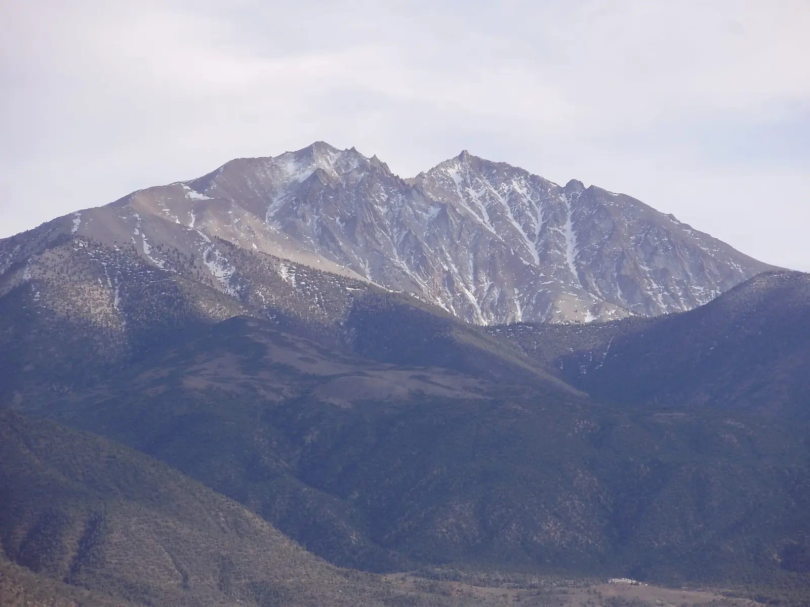
Boundary Peak is the highest point in Nevada and the northern summit of the White Mountains, rising to 4,007 m near the California border. It is a remote desert peak with broad views over the Great Basin, the Owens Valley, and surrounding ranges. The mountain is known for its long approach, dry climate, and a summit route that combines hiking with easy scrambling on loose rock.
Unlike many famous alpine peaks, Boundary Peak is usually climbed as a strenuous day outing or a simple overnight trip. The standard ascent is not technical, but the terrain is steep, exposed to sun and wind, and often covered with unstable scree. Because of its isolation, visitors should plan carefully for water, navigation, and weather.
The mountain sits inside a quiet desert landscape with few services nearby. Most climbers start from roads in the White Mountains area and continue on foot through arid slopes and ridges. The experience is valued for solitude, wide views, and the satisfaction of reaching the highest summit in Nevada.
No users yet
No routes yet.
No ascent logs yet. Be the first to log your climb!
The most common trekking route to Boundary Peak follows the standard trail and ridge approach from the White Mountains. It is a long, dry hike with steady elevation gain, loose gravel, and little shade. The route is straightforward in clear weather, but the terrain is tiring because of the altitude and the exposed desert sun. Most hikers treat it as a full-day effort and carry ample water.
Another option is to combine the summit with a longer ridge walk in the surrounding high country. These routes are less defined and suit experienced hikers who are comfortable with navigation on open slopes. They offer broader views and more solitude, but they also require careful route-finding, especially where trails fade into scree and rocky benches.
The standard mountaineering line on Boundary Peak is a non-technical ascent that becomes more serious near the upper mountain. Climbers usually follow a ridge or gully system with sections of loose rock, moderate scrambling, and occasional exposure. In dry conditions it is manageable for fit climbers, but rockfall and unstable footing are common concerns. Helmets are recommended on steeper sections.
More direct variations exist on the upper slopes, though they are rarely preferred because the rock is poor and the route is not especially efficient. In winter or after storms, the mountain can become much more demanding due to snow, ice, and wind. For most parties, the safest choice is the established summer route with an early start and conservative turnaround time.
The nearest practical base is Benton, California, a small settlement west of the mountain. From there, climbers continue on desert roads toward the White Mountains and the trailhead area used for Boundary Peak. Access is remote and road conditions can vary, so a high-clearance vehicle is helpful. In dry weather, the approach is usually manageable, but after rain or snow some roads may become rough or slow.
The closest larger service center is Bishop, California, where visitors can fuel up, buy supplies, and check weather before heading into the mountains. Reaching the trailhead generally requires driving east from Bishop and then following signed or locally known mountain roads. Cell coverage is unreliable once you leave town, so it is wise to download maps and share your plan before departure.
Guided climbs for Boundary Peak are less common than for major alpine destinations, but some regional outfitters in Bishop and the eastern Sierra Nevada offer private guiding, navigation support, or custom desert-mountain trips. Typical prices for a private guide in this area often start around USD 350 to 600 per day for one client, with higher rates for small groups, technical instruction, or multi-day logistics. Exact costs depend on season, route, and transport needs.
Well-known regional operators may include Eastern Sierra Mountain Guides, Sierra Mountain Center, and independent licensed guides based in Inyo County. Availability can be limited because Boundary Peak is a niche objective, so advance booking is important. Travelers should confirm that any guide is licensed, insured, and familiar with desert navigation, heat management, and remote first-aid procedures.
The best time to climb Boundary Peak is usually late spring through early fall, when roads are more accessible and snow is less likely on the upper mountain. June, July, September, and early October are often the most practical months. Summer can be very hot in the approach areas, so early starts are important. Afternoon thunderstorms may also develop in the warm season, especially during monsoon periods.
Winter ascents are possible for experienced mountaineers, but they are much more serious because of snow, ice, wind, and difficult access. Spring can bring lingering snowfields and muddy roads. For most visitors, a stable weather window with cool mornings and dry conditions offers the best balance of safety and comfort.
For a summer ascent of Boundary Peak, hikers should carry sturdy boots, trekking poles, sun protection, a hat, gloves, and at least several liters of water. The route is dry and exposed, so hydration is a major concern. A map, GPS device, and offline navigation app are strongly recommended because trail markings can be faint in places. A lightweight first-aid kit and extra food are also useful.
For mountaineering conditions, add a helmet, layers for wind and cold, and traction gear if snow or ice is present. In winter or shoulder seasons, an ice axe and crampons may be necessary depending on conditions. Because the mountain is remote, climbers should also carry a headlamp, emergency shelter, and a fully charged phone or satellite communicator.
The slopes around Boundary Peak support desert and high-elevation wildlife adapted to dry conditions. Visitors may see mule deer, coyotes, jackrabbits, ground squirrels, and a variety of birds of prey. In the higher and quieter areas, bighorn sheep may occasionally move through the range. Reptiles and small mammals are more active in warmer months, especially on rocky, sunlit slopes.
Because the area is remote and lightly visited, wildlife encounters are usually brief and non-threatening. Hikers should store food securely, avoid approaching animals, and watch where they place hands and feet on rocks and brush. Snakes can be present in lower, warmer terrain during the active season.
Plan for a long day and start early, especially in warm weather. The approach to Boundary Peak is remote, and water sources are not reliable, so carry everything you need from the start. Check road conditions before leaving Bishop or Benton, and expect slow travel on dirt roads. A spare tire, full fuel tank, and offline maps are essential for this area.
Because the mountain is exposed and navigation can be confusing above treeline, it is best to climb in stable weather and avoid late-afternoon storms. Tell someone your route and expected return time. If you are not comfortable with loose rock, altitude, or remote travel, consider hiring a guide or choosing a shorter objective nearby.
Boundary Peak is the highest point in Nevada, which makes it a popular state high-point objective. Despite its status, the mountain is not especially technical, and many climbers are surprised by how remote and quiet it feels. The summit area offers expansive views across the desert basin-and-range landscape, with long sightlines in clear weather.
The peak is part of a border region near California, and its name reflects that location. It is often climbed together with other high points in the region, but it remains a distinct goal because of its isolation and the effort required to reach the top.
How long does it take to climb Boundary Peak? Most climbers need about 6 to 10 hours round trip, depending on fitness, route choice, and conditions.
How long does it take to approach Boundary Peak? The road and trail approach can take 1 to 3 hours or more, depending on the starting point and vehicle access.
Is there cell service and internet on the Boundary Peak? Coverage is unreliable and often absent on the mountain and approach roads. Do not depend on mobile internet.
How difficult is it to climb Boundary Peak? It is a strenuous non-technical climb with loose rock, altitude, and a long remote approach. In poor weather it becomes much harder.
Can beginners hike Boundary Peak? Strong, well-prepared beginners may manage the standard route in good conditions, but it is not an ideal first mountain because of remoteness and exposure.
How many people climb Boundary Peak? It is climbed by a relatively small number of visitors each year compared with major peaks, mainly hikers, state high-point seekers, and local mountaineers.
No posts yet.