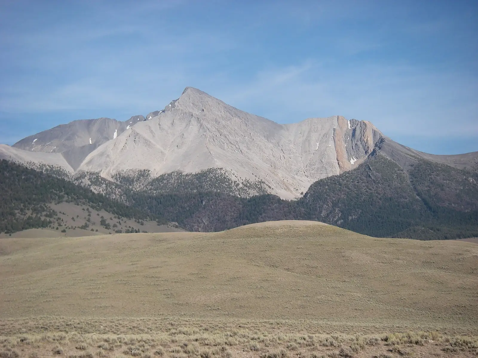
Borah Peak is the highest mountain in Idaho and the tallest point in the United States outside Alaska, rising to 3,859 m. It stands in the Lost River Range and is known for its steep, exposed slopes, long views, and demanding summit day. The mountain attracts experienced hikers and climbers looking for a strenuous alpine objective rather than a casual walk.
The standard ascent is a rugged scramble with significant elevation gain, loose rock, and route-finding challenges. In summer, the mountain is usually climbed as a long day hike, while snow can linger on upper slopes into early season. Weather changes quickly, and the summit ridge can feel much more serious than the approach suggests.
Borah Peak is popular with fit hikers, mountaineers, and peak-baggers seeking a classic western high point. The area is remote, with limited services nearby, so planning, water, and timing matter. Despite its isolation, the mountain is well known for its dramatic profile and rewarding summit panorama.
No users yet
No ascent logs yet. Be the first to log your climb!
The main trekking route is the standard Borah Peak trail from the west side, often called the Chicken Out Ridge route. It is steep from the start, with a long climb through open slopes and talus before reaching the exposed ridge near the top. The route is not a casual trek; it requires sure footing, endurance, and comfort with heights. Most hikers use it as a one-day push in stable weather.
Another common option is the same approach used more slowly as an overnight-style effort, though camping is limited and water is scarce. The route is straightforward to follow in clear conditions, but loose rock and exposure make it feel more alpine than a typical hiking trail. Trekking poles can help on the descent, especially on the scree and gravel sections.
The standard mountaineering line on Borah Peak is the west-side ascent via Chicken Out Ridge, the most climbed and best-known route. It combines steep hiking, scrambling, and a narrow summit ridge with moderate exposure. In dry summer conditions it is the preferred route for strong climbers, but snow or ice can increase difficulty significantly and may require traction and an ice axe.
Alternative lines exist on the mountain’s steeper faces and ridges, but they are less commonly used and more serious, with loose rock and greater objective hazard. These routes are generally chosen by experienced mountaineers seeking a more technical outing. For most visitors, the standard route offers the best balance of access, challenge, and summit success.
The usual starting point for Borah Peak is near the small community of Challis, with the approach continuing toward the trailhead in the Lost River Range. From the nearest larger hub, Idaho Falls, the drive is long and rural, with mountain roads leading to the trailhead area. The final access road can be rough, so high-clearance vehicles are helpful, especially after rain or early snow.
Most climbers reach the trailhead by driving from Challis or from the Salmon-Challis National Forest road network. There is no public transport to the mountain, so a private vehicle is necessary. Cell coverage is unreliable or absent once you leave town, and the approach should be planned with fuel, maps, and enough time for the return drive.
Guided climbs for Borah Peak are usually arranged through regional mountain guides rather than large commercial tour operators. Well-known options in Idaho and the broader Rocky Mountain region include Idaho Mountain Guides, Exum Mountain Guides, and International Alpine Guides. Prices vary by season, group size, and whether the trip is private or shared, but a guided summit day commonly starts around USD 300 to 700 per person, with private trips costing more.
Because services change frequently, it is best to confirm current rates directly with the guide service before booking. Some agencies offer custom logistics, route instruction, and gear advice rather than fixed-package tours. For a remote peak like Borah Peak, a guide can be useful for first-time visitors who want help with pacing, route-finding, and mountain safety.
The best time to climb Borah Peak is usually from late June through September, when the route is mostly snow-free and the weather is more stable. July and August are the most popular months because the trail is easier to follow and the summit ridge is less likely to hold dangerous snow. Early season climbs can still encounter lingering snowfields on upper slopes.
Morning starts are strongly recommended, since afternoon thunderstorms and strong winds can develop quickly in the Lost River Range. Autumn can bring colder temperatures and early snow, while spring conditions are often too snowy for a straightforward ascent. A clear forecast and dry rock make the climb much safer and more enjoyable.
For a summer ascent of Borah Peak, climbers should carry sturdy hiking boots, layered clothing, gloves, sun protection, plenty of water, and navigation tools. Trekking poles are useful on the descent, and a helmet is a smart choice because of loose rock on the upper mountain. A headlamp is essential for early starts or late finishes.
If snow remains on the route, add an ice axe and traction such as microspikes or crampons, depending on conditions. Because the mountain is remote, bring extra food, a first-aid kit, and emergency insulation. Weather can change fast, so a windproof shell and warm layer are important even in midsummer.
The slopes around Borah Peak are home to typical high-desert and alpine wildlife. Hikers may see mule deer, elk, bighorn sheep, marmots, pikas, and a variety of birds of prey. In the lower country, smaller mammals and sagebrush species are common, while the upper mountain supports hardy animals adapted to wind, rock, and cold.
Wildlife sightings are most likely early in the morning or near water sources. Visitors should keep a respectful distance and avoid feeding animals. In remote areas, it is also wise to store food securely and watch where you step, especially around talus and brushy sections.
Plan for a long day and start early, since Borah Peak is a strenuous climb with little shade and a lot of elevation gain. Check road conditions before leaving town, because access roads can become rough or muddy. Bring more water than you think you need, as reliable water sources are limited on the route.
Navigation matters on the upper mountain, especially in fog or wind. Tell someone your plan, expected return time, and vehicle location. If you are not comfortable with exposure or loose rock, turn back before the summit ridge. The mountain is remote, so self-sufficiency is important.
Borah Peak is the highest point in Idaho and one of the most prominent summits in the state. Its summit ridge is famous for the phrase Chicken Out Ridge, a name that reflects the exposed nature of the final section. The mountain rises sharply from a remote basin, making its profile especially striking from the surrounding valleys.
Because of its isolation, the peak offers a true backcountry experience rather than a crowded tourist climb. On a clear day, the summit provides wide views across the Lost River Range and beyond. The combination of height, remoteness, and exposure makes it a memorable objective for experienced hikers.
How long does it take to climb Borah Peak? Most climbers need about 8 to 12 hours round trip, depending on fitness, conditions, and pace.
How long does it take to approach Borah Peak? The drive and trailhead approach usually take several hours from the nearest larger towns, with the final road adding extra time.
Is there cell service and internet on the Borah Peak? Coverage is unreliable or absent on the mountain and along much of the approach.
How difficult is it to climb Borah Peak? It is a strenuous climb with steep grades, loose rock, and exposure near the summit.
Can beginners hike Borah Peak? Strong, well-prepared beginners may attempt it in good conditions, but it is not an ideal first mountain.
How many people climb Borah Peak? Numbers vary by season, but it is a popular peak and sees regular summer traffic from hikers and climbers.
No posts yet.